
Interactive Town Map
Mashpee Interactive Map(click here)
Geographic Information System (GIS) is defined as an information system that is used to input, store, retrieve, manipulate, analyze and output geographically referenced data or geospatial data, in order to support decision making for planning and management of land use, natural resources, environment, transportation, urban facilities, and other administrative records.
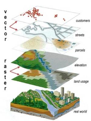
GIS is a tool that allows for easy interpretation of complex, real-world scenarios. GIS is a series of spatial layers made up of vector (points, lines and polygons) and raster (images, pixels) data. By using these data layers, a user can visualize AND analyze the ways certain information interacts with other information. Layers often have many fields of information describing their characteristics, for example, a parcels layer might have information describing the physical traits such as area and location but also other data such as street address, owner name and sales history. The types of analysis done using GIS vary greatly by the project the user is working on. For example by using a GIS we can see the ways topography effects the amount of buildable land on a certain parcel, or we can query all of the properties in town that have a resident identified as mobility impaired for use by the fire department during an emergency.
GIS Illustrated:
The Town of Mashpee has a well-maintained GIS and makes it available to the public through this website. Please click the link below:
Mashpee Interactive Map (Click Here)
If you have any questions or concerns with the Town's GIS, please e-mail the GIS Coordinator.
Disclaimer:
The Town of Mashpee makes no claims, no representations and no warranties, express or implied, concerning the validity (express or implied), the reliability or the accuracy of the GIS data and/or GIS products furnished by the Town, including the implied validity of any uses of such data. Parcel lines are graphic representations only.